John French's Highpoints
John French's Highpoints!
© 2010 John French
#15

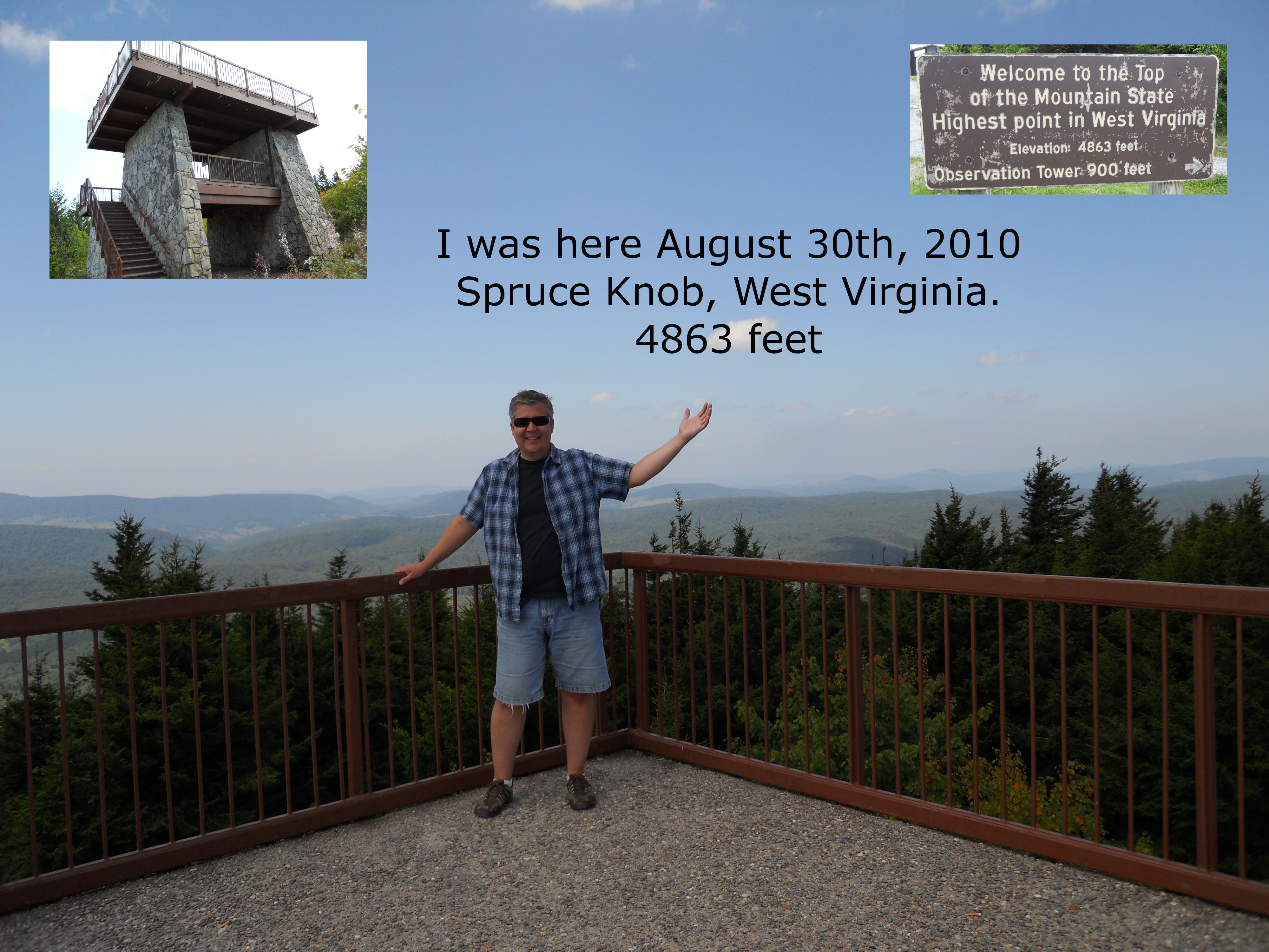
I got to my 15th highpoint on the way back from a trip to visit my Mom and Dad in Sunset Beach, NC. Just before I went to the WV highpoint, Spruce Knob, I visited the radio telescopes at Green Bank, West Virginia. I highly recommend a visit there. Spruce Knob can be accessed by two roads, one from the south and one from the north. I went up the south route and back down the north route. The southern route is a fun gravel windy and twisty road for about 17 miles. The northern route is shorter and paved. There's an observation tower at the summit. You park in the lot and have to walk about 300 yards to the tower according to the sign. There's some cool boulder fields along the side of the trail. It didn't feel like 3 football fields of a walk though. I forgot my binoculars in the truck and had to walk back to get them. It just took a few minutes. The weather was very nice. I talked to a family from Maryland when I got there. Another family from Virgina and Pennsylvania were there when I left. I took a few photos and made a nice panorama with my Nikon Coolpix S570 camera and tripod. I left the highpoint and drove north to Seneca Rocks. Then started back to Michigan. Winding through the hills of West Virgina always takes longer than I plan for. It's a lot of fun. I didn't get home until 3 a.m. and had to get up early the next morning for a closing on the refinance for my house. I got to the closing on time at 9 a.m. but they made me wait two hours before they were ready with the papers. It worked out good though, I saved a bunch of money.
August 30th, 2010 2:15 pm EDT
#14
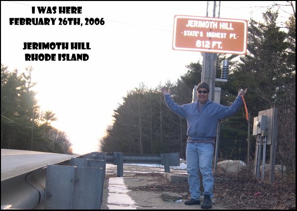
I didn't spend much time at this highpoint. It was reached on a trip to visit Brown University in Providence, Rhode Island. I was taking Michaelena to look at the school. Rebekah and Therese were in the car too. We stopped in Poughkeepsie, New York the day before, then drove across the state of Connecticut. Just across the Rhode Island border on Route 101, I saw the sign, stopped the car, and hopped out to take the photo. The girls all thought I was crazy. I ran back across the street and we continued our journey in the overpacked Honda Civic. Rebekah had two suitcases for the four day trip. I ask her why she had so much clothes. She said her mom told her, "To figure out how many outfits to bring, count the number of days, double it, then add two." And they thought I was crazy! If I'm ever back in the area on a weekend between 8am and 3pm (the official visiting hours), I'll look for the exact highpoint spot. But for now, the road sign will have to do.
February 26th, 2006 5:00 pm EST
#13
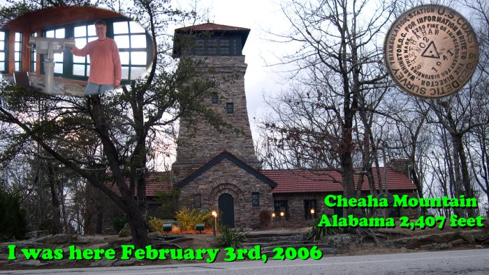
This is the first time I made it to two highpoints in one day. It was about a six hour drive from the Florida highpoint. This feels a lot more like a highpoint than Florida. It's 2407 feet above sea level. The summit is in Cheaha State Park. But the "US Coast and Geodetic Survey" marker in the sidewalk in front of the observation tower says "Cheehahaw" There is even a lodge in the park that you could stay in. It might have been a better place to stay in than the ratty motel I ended up staying in in Huntsville. At the top of the mountain is a nice old observation tower. The view is really exceptional. Even thought the sun was setting and it was a cloudy day, I could see for many miles in all directions. The weather was changing. It was getting much colder as it was getting dark. I didn't spend too much time at the summit because I wanted to travel farther north before it got too late. I took a few photos, then drove out of the park and down the mountain.
February 3rd, 2006 4:45 pm CST
#12
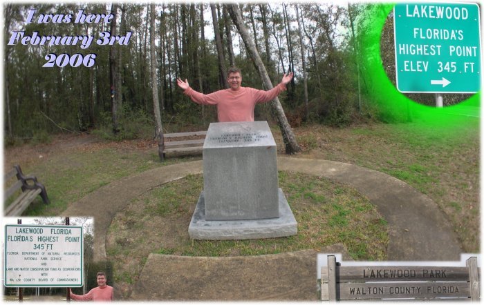
Florida's highpoint is the lowest highpoint in the USA. Only 345 feet above sea level. I made it to this spot on my winter break 2006. I took a long trip from Michigan to New Jersey, to North Carolina, to Florida and Alabama then back to Michigan. The night before I attempted the summit, I stayed in Tallahassee. The day before, I was in the Atlantic Ocean at Cocoa Beach. The highpoint is about two and a half hours west of the state capital in the Florida panhandle. There's a nice little park at the highpoint with some picnic benches and a restroom. It looked like the stone marker might not be at the exact highest point. It might be in the woods behind the marker. Across the road was a nice view of a rolling field. It's an easy to find highpoint with plenty of signs on the roads leading up to the summit. I left this place after a few pictures and signing the guest book. Then I headed off to the Alabama highpoint.
February 3rd, 2006 10:30 am CST
#11
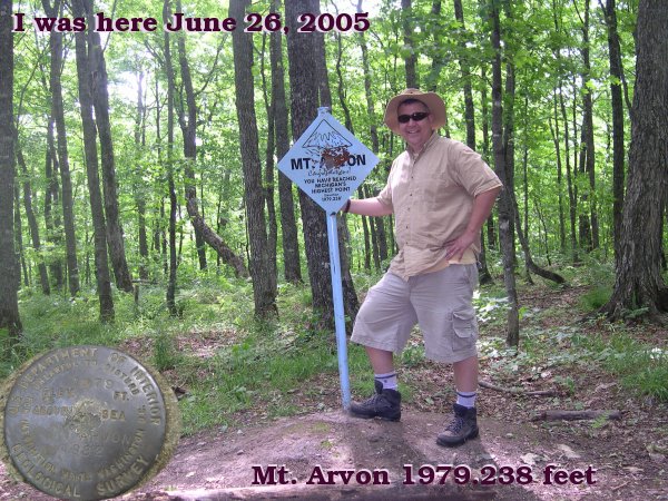
This highpoint was visited after a planetarium meeting in Marquette, Michigan. Michigan's highest point is in the U.P. (upper peninsula) The folks that live up there are known as yoopers (pronounced: YOU'-pers). From Marquette, I traveled west on US route 41 towards L'Anse. From L'Anse we went towards Skanee. Jen and Shane Horvatin were following me for their first highpoint adventure. The guidebook I had was real helpful. The road to the summit was long and dusty with several Y's in the road. Without a guidebook, one could easily get lost. Close to the top, the roads got very rough. Lots of potholes and rocks, but my Geo Metro made it through no problem. It was a fun and exciting drive up the mountain. The Horvatin's were close behind in their Subaru, eating my dust. Within about 3/4 of a mile from the top, we had to park the cars and walk the rest of the way up. It was about a 15 minute easy walk. At the peak, there is no view. You're in amongst tall trees. A viewing tower like the ones in Wisconsin and Pennsylvania would be a nice addition. At the top, there are a few benches and a picnic table. BSA troop 216 supplied a sign in box on a tree. There was even a BBQ grill and a fire pit available. We looked around for about 10 minutes and headed down the trail. Near the "base camp" there was a small pond and we spotted what looked like a family of mergansers swimming on the water. We drove back to L'Anse and ate dinner at a local bar and grill. Everyone in the place had a funny yooper accent. I had the "Bodacious Wet Burrito" since we were, "south of the border".
June 26th, 2005 4:05 pm EDT
#10
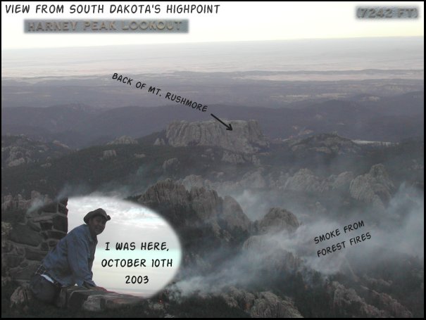
I went to Custer State Park after visiting Mt Rushmore and Devil's Tower earlier in the day. It was a $5.00 fee to get into the park. I was told that both trails 4 and 9 went to Harney Peak. I went up trail 4 and came back down on trail 9. Trail 9 turned out to be the faster route. It's about a 3 mile hike each way. I started up about 3:30 and made it to the summit around 5:30. The weather was great on way up but a front was on its way. The view at top was wonderful. You can see the back of Mt Rushmore. It was very windy at summit. I didn't stick around long because it was starting to rain. I hurried back to trailhead and made it there by 6:30. I was cold and wet and it was getting dark. The plaque on the tower claims Harney Peak to be highest point betwixt the Rockies and the Pyrenees in Europe!
October 10th, 2003 5:30 pm MDT
#9
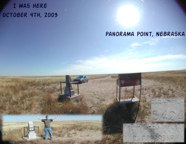
I stopped at Panorama Point on my way to Salt Lake City from Michigan. It's about 10 miles from I-80, dusty dirt roads all the way from the interstate. There's a whole lot of nothing in that part of Nebraska. I put my two dollars into the pay box to get into the highpoint park. As I drove up the last few yards to the highpoint, my ears popped! There was abundant sunshine and a stone marker surrounded by a steel railing. An old desk of some sort was there with a guest book inside the drawer. I signed my name and took a few photos. Looking around, I was reminded of Buzz Aldrin's famous words, "A magnificent desolation".
October 4th, 2003 12:40 pm MDT
#8
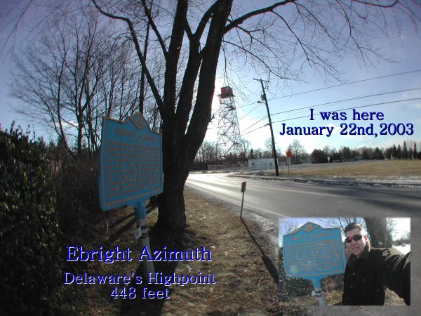
I stopped at this highpoint after leaving my brother's house in New Jersey where we built a 200 pound trebuchet. (It threw a cantaloupe about 100 feet.) This high point is not very dramatic. It's located in the suburbs of Wilmington. The area is somewhat flat and it's not clear where the exact high point is. The sign says "this bench mark monument is in the vicinity of the highest natural elevation in the state". It does look as if the ground under the 1st row of trailers, in the mobile home park across the street, is a bit higher, but that ground doesn't look natural. So where is the highpoint? I don't know. The day I was there was a good looking day, very blue sky. But it was cold, only about 15 F. So I didn't feel like hanging around outside the car too long. From here I traveled south and crossed the Chesapeake Bay Bridge Tunnel on my way to North Carolina.
January 22nd, 2003 2:30 pm EST
#7

Mount Mitchell, North Carolina's highpoint was my 7th highpoint to date. I visited this highpoint on a trip to see my Mom and Dad. We started in Ashville NC and got on the Blue Ridge Parkway heading north. At the folk art center, a park ranger told us the Blue Ridge Parkway was closed ahead due to ice. We had to turn back and attempt the summit from the north. We got off the Parkway and headed east on I-40 and then went north on NC-80, which is a very long and winding road. Once on the Blue Ridge Parkway again, we went south to Mt. Mitchell State Park. There is a nice museum and gift shop near the summit. The weather was perfect, very few clouds, about 50. There was some snow on the ground in a few sparse patches. The walk up to the top of the mountain from the parking lot is about 285 yards according to the historical marker that talks about Rev. Elisha Mitchell D.D. who died on the mountain trying to measure its height. Dr. Mitchell tried to prove that this summit was the highest point east of the Mississippi River.
November 9th, 2002 12:47 am EST
#6
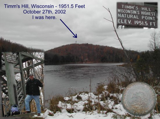
I went to this highpoint after the GLPA meeting in Neenah Wisconsin. The day was grey and overcast. The highpoint was easy to find. It's in a county park. There's a 300 yard walk up to the summit from the parking area. The trail was covered with wet leaves. Two people and a dog were walking down the trail as I was going up. At the summit there are two towers. One is for anyone to climb. It has steps. The other one is some sort of fire tower or something. It's taller but it had a ladder to its top. I went up the one with the steps. There was a lot of ice on the steps and it was kind of slippery. It seemed to be about 30 that day. Two small lakes can be seen from the observation tower. There's another hill just to the west of Timm's Hill. It seemed almost as high. There was a United States flag on the tower. Wind must have wrapped it around the flag pole. I unfurled the flag so it could wave in the breeze. I took a few pictures. Another family arrived as I was leaving. When I left, I went south in Wisconsin and found the center of the northern half of the western hemisphere of the planet Earth. 45.00N Latitude 90.00W Longitude. Very cool!
October 27th, 2002 10:45 am CST
#5
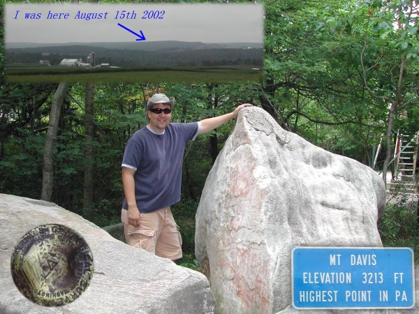
I went to this highpoint after a trip to Johnstown PA. We left Johnstown in the morning and went south on US Route 219 passing some hugh windmills along the way. We also stopped at a covered bridge near Meyersdale. Once to the highpoint we took some photos, then Rebekah and I climbed the observation tower while Therese watched from below. Mt. Davis is an easy highpoint to reach. It's in a very beautiful part of Pennsylvaina. The actual highpoint is on the top of a big rock. There is a lot of information to read there about the geology and history of the area but we left before I was able to read all the informational exibits. Two other people came by while we were there and left before we did. While you are standing at the highpoint, it's hard to tell you are at the highest place in the state. But from the tower, it is quite a nice view.
Aug 15,2002 2:07 pm EDT
#4
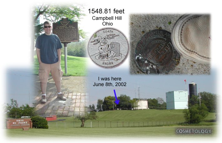
I drove to Ohio's highpoint on backroads from Holt, MI. It
was a nice sunny summer day. It was easy to find the
highpoint, but getting to Bellefontaine, Ohio took longer
than I thought it would. It seems like there are no direct
roads from Holt to Bellefontaine. A bridge was out on one road.
The detour added about a half an hour to the trip. The highpoint
is a nice one. Very clean. there's a couple of benches at the
summit along with a flag pole. The historical marker says that
this was a NORAD radar site during the cold war. Now it's a
cosmetology school! Well, they call it a vocational education
center. While there, I saw a small sparrow. I think it was a
"chipping" sparrow.
June 8, 2002 6:00 pm EDT
#3
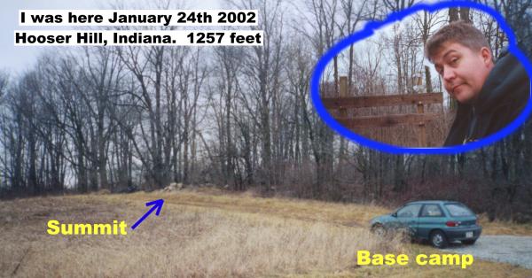
I stopped at this highpoint on my travels from Texas to Michigan
when I was starting my new job at the Abrams Planetarium. It was
a cold day, around 35 degrees. The sky was overcast. I parked at the
side of the road and walked to the summit. If they didn't tell you
it was a high point, you'd never know it was. For me the top of
Indiana is special because it's the state where I was born. When
standing at the spot, you can see a nice view of the corn fields
down below the summit, about 10 feet below!
#2
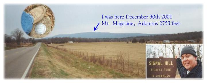
My second highpoint was Arkansas. I drove to this highpoint going west on Interstate 40
from Hazen, Arkansas where I stayed the night before the ascent. I was traveling from
Michigan. I stopped in Indiana and visited the George Rogers Clark National Historic
Park and Abraham Lincolns Boyhood Home National Memorial on my way to Texas.
From I-40 I went through Russellville and Dardanelle on route 7 to route 27 to route 10.
I then drove up Mt. Magazine in the Ozark Mountains. Once to the state park, I found
the trail to Signal Hill. There was some yellow caution tape blocking the entrance to the
trail. I ignored it and started up the trail. It was about a 1/2 mile to the summit. No one
was around. I took a few photos. It was quite cold, maybe around 25 degrees. There
wasn't much of a view because of the trees, but you could tell you were at a high point. I
started down and as I was almost to my car, another highpointer was going up. Near the
parking area is a hang glider launch point called Danger Bluff. I dont know if that's its
name or a warning sign. The view there is great. A snow storm was clearly heading
towards me and quickly covered the view. As I watched the snow come in I heard and
then saw a Pileated Woodpecker in the trees. Then I drove down the mountain and went
towards Hot Springs Arkansas, into Texas and home. It was a very nice trip! I sure do need to get a tripod on my camera. Taking these photos with an arm streched out just isn't the best!
#1
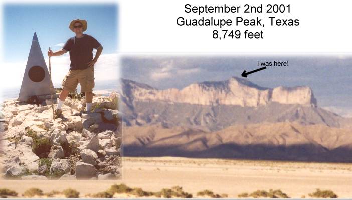
Texas was my first highpoint. 49 more to go! On this trip, I camped out
at Monahans Sandhill State Park the night before. The park is filled
with sand dunes. It's a really nice place to camp. The full moon was
out all night. The next morning I drove through Pecos Texas and on
to Guadalupe Mountains National Park. The visitors center has a nice
exhibit explaining the geology of the area and includes stuffed examples
of the wildlife in the mountains. I started my assent at 11:20 am with two
liters of water and four granola bars. I reached the summit at 2:10 pm with
one liter of water left. I took a few photos, ate my lunch, then asked two
other hikers to take my picture at the summit. I took a picture of them too.
They started down and three more people came up and I took their picture
for them. I started down at 2:55 pm and reached the trailhead at 5:05 pm.
So the round trip hike was 5 hours and 45 minutes! I was tired, dirty
and sore, but it was well worth it! I then drove to El Paso and stayed
in a motel and went to Juarez Mexico the next day.
| State |
Peak |
Height |
Vertical Climb (feet) |
Round Trip Hiking Mileage |
Class |
Height Rank |
Difficulty Rank |
Date Done |
| Alaska |
Mount McKinley |
20,320 |
13,000 |
46 |
10 |
1 |
1 |
|
| Wyoming |
Gannett Peak |
13,804 |
8,650 |
40.4 |
9 |
5 |
2 |
|
| Montana |
Granite Peak |
12,799 |
7,700 |
22.2 |
9 |
10 |
3 |
|
| Washington |
Mount Rainier |
14,411 |
9,100 |
16 |
9 |
4 |
4 |
|
| Oregon |
Mount Hood |
11,239 |
5,300 |
8 |
8 |
13 |
5 |
|
| Idaho |
Borah Peak |
12,662 |
5,550 |
6.8 |
8 |
10 |
6 |
|
| Utah |
Kings Peak |
13528 |
5,350 |
28.8 |
7 |
7 |
7 |
|
| California |
Mount Whitney |
14,494 |
6,750 |
21.4 |
7 |
2 |
8 |
|
| Colorado |
Mount Elbert |
14,433 |
5,000 |
9 |
6 |
3 |
9 |
|
| Arizona |
Humphreys Peak |
12,633 |
3,500 |
9 |
6 |
12 |
10 |
|
| Nevada |
Boundary Peak |
13,143 |
4,400 |
7.4 |
6 |
9 |
11 |
|
| New Mexico |
Wheeler Peak |
13,161 |
3,250 |
6.2 |
6 |
8 |
12 |
|
| Texas |
Guadalupe Peak |
8,749 |
2,950 |
8.4 |
5 |
14 |
13 |
02-Sep-2001 |
| New York |
Mount Marcy |
5344 |
3,200 |
14.8 |
5 |
21 |
14 |
|
| Maine |
Katahdin (Baxter Peak) |
5,267 |
4,200 |
10.4 |
5 |
22 |
15 |
|
| Virginia |
Mount Rogers |
5,729 |
1,500 |
8.6 |
4 |
19 |
16 |
|
| Oklahoma |
Black Mesa |
4,973 |
775 |
8.6 |
4 |
23 |
17 |
|
| Minnesota |
Eagle Mountain |
2,301 |
600 |
7 |
4 |
37 |
18 |
|
| South Dakota |
Harney Peak |
7,242 |
1,500 |
5.8 |
4 |
15 |
19 |
10-Oct-2003 |
| Connecticut |
Frissel-S. Slope |
2,380 |
450 |
3.6 |
3 |
36 |
20 |
|
| Vermont |
Mount Mansfield |
4393 |
550 |
2.8 |
3 |
26 |
21 |
|
| Maryland |
Backbone Mountain |
3360 |
750 |
2.2 |
3 |
32 |
22 |
|
| North Dakota |
White Butte |
3,506 |
400 |
2 |
2 |
30 |
23 |
|
| Michigan |
Mount Arvon |
1,979 |
300 |
2 |
2 |
38 |
24 |
26-Jun-2005 |
| Louisiana |
Driskill Mountain |
535 |
150 |
1.8 |
2 |
48 |
25 |
|
| Georgia |
Brasstown Bald |
4,784 |
400 |
1 |
2 |
25 |
26 |
|
| Tennessee |
Clingmans Dome |
6,643 |
330 |
1 |
2 |
17 |
27 |
|
| Arkansas |
Mt. Magazine (Signal Hill) |
2,753 |
225 |
1 |
2 |
34 |
28 |
30-Dec-2001 |
| Rhode Island |
Jerimoth Hill |
812 |
25 |
0.6 |
1 |
46 |
29 |
26-Feb-2006 |
| Hawaii |
Mauna Kea |
13,796 |
230 |
0.4 |
1 |
6 |
30 |
|
| Wisconsin |
Timms Hill |
1,951 |
130 |
0.4 |
1 |
39 |
31 |
27-Oct-2002 |
| Illinois |
Charles Mound |
1,235 |
75 |
0.4 |
1 |
45 |
32 |
|
| Missouri |
Taum Sauk |
1,772 |
30 |
0.4 |
1 |
41 |
33 |
|
| West Virginia |
Spruce Knob |
4,863 |
20 |
0.4 |
1 |
24 |
34 |
30-Aug-2010 |
| North Carolina |
Mount Mitchell |
6684 |
100 |
0.2 |
1 |
16 |
35 |
9-Nov-2002 |
| New Jersey |
High Point |
1,803 |
40 |
0.2 |
1 |
40 |
36 |
|
| South Carolina |
Sassafras Mountain |
3,560 |
30 |
0.2 |
1 |
29 |
37 |
|
| New Hampshire |
Mount Washington |
6,288 |
20 |
0.1 |
1 |
18 |
38 |
|
| Massachusetts |
Greylock |
3491 |
20 |
0.1 |
1 |
31 |
39 |
|
| Indiana |
Hoosier Hill |
1,257 |
20 |
0.1 |
1 |
44 |
40 |
24-Jan-2002 |
| Iowa |
Hawkeye Point |
1,670 |
10 |
0.1 |
1 |
42 |
41 |
|
| Kentucky |
Black Mountain |
4,145 |
- |
0.1 |
1 |
27 |
42 |
|
| Nebraska |
Panorama Point |
5,424 |
- |
0 |
1 |
20 |
43 |
4-Oct-2003 |
| Kansas |
Mount Sunflower |
4,039 |
- |
0 |
1 |
28 |
44 |
|
| Pennsylvania |
Mount Davis |
3,213 |
- |
0 |
1 |
33 |
45 |
15-Aug-2002 |
| Alabama |
Cheaha Mountain |
2,407 |
- |
0 |
1 |
35 |
46 |
3-Feb-2006 |
| Ohio |
Campbell Hill |
1,549 |
- |
0 |
1 |
43 |
47 |
08-Jun-2002 |
| Mississippi |
Woodall Mountain |
806 |
- |
0 |
1 |
47 |
48 |
|
| Delaware |
Ebright Azimuth |
448 |
- |
0 |
1 |
49 |
49 |
22-Jan-2003 |
| Florida |
Lakewood (Britton Hill) |
345 |
- |
0 |
1 |
50 |
50 |
3-Feb-2006 |
Links:
Highpointers Club (Note: I'm not a member)
My Moon Photo pages.
My Moist Towelette Museum page.